How to Quiz Yourself on a Map From a Geography Textbook
You stare at the map of South America for twenty minutes, close the book, and can't place Paraguay. That's normal. Looking at a map feels like learning, but recognition is not recall. This guide shows you how to quiz yourself on a map from a geography textbook in five steps, so you can find places, read the legend, and explain patterns without the page in front of you.
How to quiz yourself on a map from a geography textbook: why rereading rarely sticks
When you reread a map, your eyes do the work. Every label is right there, so your brain never has to pull anything out of memory. You get a feeling of "I know this," and then the exam hands you a blank outline and the feeling disappears.
Quizzing forces retrieval: you try to remember where the Andes run or what the shaded band in the legend means, and then check. It works for maps, not only words. In a 2007 experiment, people studied two maps, one by looking and one by recalling a feature that had been deleted from it. Half an hour later, they drew the tested map better.
Maps add a second problem. They hold several kinds of information at once: names, positions, symbols, scale, and patterns like population density or climate zones. If you only drill place names, you miss the questions that ask you to interpret the map. The steps below cover both.
Step 1: Decide what the exam will actually ask about the map
Before you quiz anything, look at how your teacher tests maps. Check old quizzes, the study guide, or the end-of-chapter questions. Most map questions fall into three groups:
- Location: "Label the five Great Lakes." "Which country borders both Brazil and Peru?"
- Reading the map: "Using the scale, how far is it from A to B?" "What does the dark green shading show?"
- Patterns and reasons: "Why are most cities in this region along the coast?" "Which area would you expect to have the least rainfall, and why?"
Write a short list for the map you are studying. For example, for a map of Africa's climate zones: 10 countries to locate, the meaning of each legend color, and two patterns (desert belts near the tropics, rainforest along the equator). That list is your target. Anything not on it can wait.
Step 2: Blank out the labels and recall locations from memory
Now make a version of the map without the answers. You have a few easy options:
- Lay a sheet of tracing paper over the map and trace only the outlines.
- Cover the labels with small sticky notes.
- Print a blank outline map of the same region, if your class provides one.
Then work through your list. Point to or write each place from memory. Say it out loud if that helps. Don't peek until you have tried every item. Then check against the textbook and mark each one right or wrong.
Keep the wrong ones in a separate list. That short list is what you will drill next time. If you got Chad and Niger mixed up, write down what tells them apart ("Chad has Lake Chad on its western edge"). A small cue like that is easier to recall than a shape.
Step 3: Quiz the legend, scale, and key patterns, not just place names
This step is easy to skip. Cover the legend and ask yourself what each color, line, or symbol means. Then reverse it: look at the legend and find an example of each symbol on the map.
For scale, pick two points and estimate the distance before you measure. For patterns, ask "where" and "why" questions:
- Where is the highest population density on this map?
- What physical feature explains that?
- Which region breaks the pattern, and what might cause that?
If your map comes with a data table beside it (populations, rainfall, exports), quiz that too. The method in how to quiz yourself on a data table from a textbook works well for the numbers that go with a map.
Step 4: Turn the map into question-and-answer flashcards
Flashcards let you shuffle and drill without the whole map open. Write one question per card. Mix the three types from Step 1:
- "Which river forms much of the border between Mexico and the United States?" (the Rio Grande)
- "On the climate map, what does the orange band represent?"
- "Why does the Sahara sit where it does on the map?"
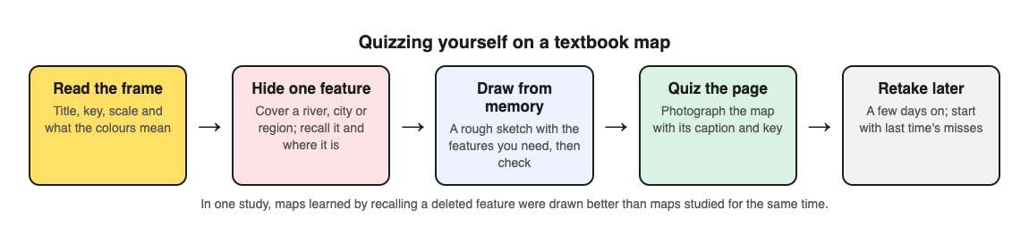
You can also have a tool write the questions for you. Multiple-choice quizzes have helped in a real classroom: in sixth grade social studies, low-stakes quizzes raised chapter and semester exam scores on the quizzed material. With Study Shot, you photograph the textbook page and an AI model writes multiple-choice questions about it, each with four choices and one right answer. Here is a simple workflow for a map page:
- Tap Make a new quiz, then Take photo or Choose photo. Hold the page flat and fill the frame so the labels and legend are readable. Diagrams work, and so does a page with a map and its caption.
- Choose how many questions: 5, 10, 15 or 20. Ten is the default and a good size for one map.
- Choose a level. Basic covers key terms and facts, like what a symbol means. Intermediate asks you to explain and compare. Advanced asks you to apply and predict in new situations, which suits the "why" questions about patterns. Tiered, the default, climbs from basic to advanced.
- Pick the quiz language, then press Create questions. It can take up to a minute.
You answer one question at a time. After Check answer, you see whether you were right, the correct answer, and a short explanation. If you forget what part of the map a question refers to, tap Show page to see your photo again.
One honest note: the questions are written by an AI model, so they can contain mistakes, especially if a label in the photo is small or blurry. Read the explanation and check it against the map. If a question is wrong, use Report a problem with this question under it. Multiple choice also tests recognition more than pure recall, so pair it with the blank map from Step 2 and the redraw in Step 5.
Step 5: Redraw the map from memory and check what you missed
This is the hardest test and the best one. Close the book. On blank paper, sketch the region as well as you can. Add the places on your list, a simple legend, and arrows or shading for the main patterns. It does not need to look good. Rough shapes in the right places are enough.
Then open the textbook and compare. Circle every gap or error in a different color. Those circles tell you what to study next.
Space your map quizzes so they last until test day
Spread short sessions over several days instead of one long session the night before. Our post on studying for a geography test from your notes covers the rest of the course. A simple plan for a map due in a week:
- Day 1: Steps 1 to 4. Make your list, do the blank map, take a quiz.
- Day 2: Quiz only the items you missed. Redraw the map once.
- Day 4: Full quiz again, then a redraw.
- Day 6 or the day before: One last quiz and redraw. Review only the circled gaps.
Study Shot saves each quiz to your library with its page photo and your best score, so retaking it on Day 4 is one tap on Retake quiz. The results screen also gives a score for each level and a Look at these again list with your answer and the right answer for each miss. Use that list as your Day 2 study sheet. If you are in a study group, Share this quiz makes a link. Each person who opens it needs an account and gets their own copy of the questions, without your photo.
Frequently asked questions
How many places should I quiz from one map at a time?
Start with 8 to 12. That is enough to make progress without mixing up similar shapes. Once you get them right on two separate days, add the next batch.
What if my textbook map is too detailed to memorize?
You almost never need all of it. Use Step 1 to pick only what your exam asks for, and ignore the rest. If you photograph the page for a quiz, you can also photograph just the part of the map you need, which keeps labels larger and easier to read.
How is quizzing a geography map different from reading a historical map?
A geography map usually tests where things are and why physical or human patterns appear. A historical map adds time, so you also need to know when borders or routes changed and what caused it. The recall steps here still apply, but you add dates and causes to your questions.
Pick one map from your current chapter. Make your list, do one blank-map round, and then quiz the page so you test the legend and patterns too.
Get started
Try Study Shot: it is free to start. Photograph the page you are studying tonight and get 10 practice questions on it, from basic to advanced.
Comments
No comments yet.
Sign in or make an account to comment.