How to read a historical map: 4 steps for students
If you want to know how to read a historical map, start with one idea: a map is a document, made by someone, at some time, for some reason. Read it the way you would read a letter or a speech. The four steps below come from the National Archives document analysis worksheets, which teach the same careful reading for photos, written documents, posters and maps alike. This post explains each step, then walks you through one real map.
Why a map needs reading, not just looking at
A map looks like plain fact. It shows where things are. But every map leaves things out, and the choice of what stays in tells you about the person who made it and the reason they made it.
So the question is never only "what does the map show?" It is also "who made this, when, and why?" That is the same question you ask of any source, as our guide to how to analyze a primary source explains.
One more point before the steps. A map drawn at the time of the events is a primary source. A map made today to show the past is a secondary source: someone's summary of what historians know. Both are useful, but you read them differently. Our post on primary vs secondary sources has more examples.
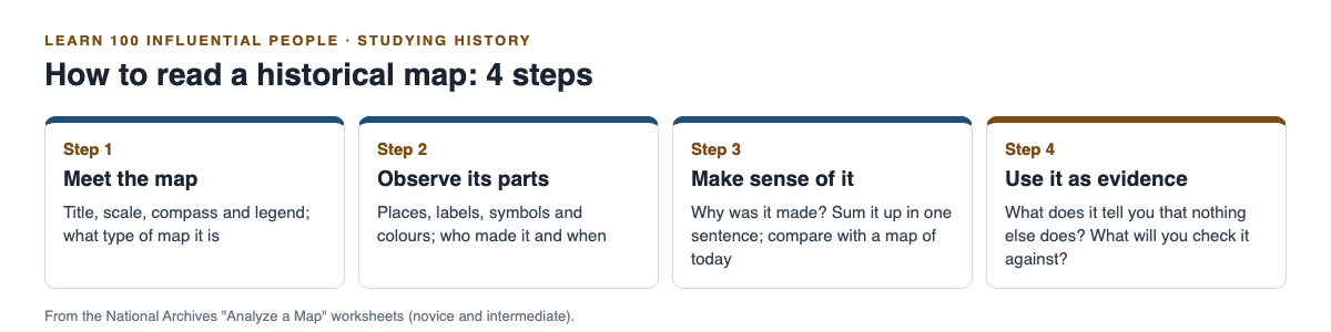
The four steps, in the order the worksheets use them.
Step 1: Meet the map
Start with what is printed on it. The National Archives' novice map worksheet asks three things: does the map have a title, does it have a compass rose, a legend and a scale, and do the symbols or colours in the legend stand for something?
The intermediate worksheet adds one more question: what type of map is it? Its list includes political, physical, exploration, military, transportation, and population or settlement maps. Naming the type tells you what the mapmaker cared about.
Step 2: Observe its parts
Now look closely. What places are shown? What is labelled, and what is not? If there are symbols or colours, what does each one stand for?
The novice worksheet gives a checklist to circle: mountains, rivers, lakes, oceans, cities, states, countries and roads. Tick what the map includes. What it leaves out matters too: a map of armies may show cities and roads but no rivers, because the mapmaker cared about routes, not water.
Then find two facts that matter more than anything else: who made the map, and when it is from. The intermediate worksheet asks both directly. A map with no maker and no date is much harder to use as evidence.
Step 3: Try to make sense of it
This is where you think, not just look. The intermediate worksheet asks what was happening at the time the map was made, and why it was created. It asks you to list the evidence, from the map or from what you know about the mapmaker, that led you to your answer.
The novice worksheet puts it simply: why do you think this map was made? List two parts of the map that tell you this. Naming the parts keeps your answer tied to the evidence, not to a guess.
Two more tasks finish the step. Write one sentence that sums up the map. Then compare it with a current map of the same place: what has changed, and what has stayed the same?
Step 4: Use it as historical evidence
The last step turns the map into evidence for an argument. The worksheet's key question is this: "What did you find out from this map that you might not learn anywhere else?"
Then ask what other documents or evidence you will use to check it. A map on its own rarely proves a point. Next to a chronicle, a letter or a timeline, it can show you how far, how fast or how close. The National Archives page makes the same point: "Analysis is just the foundation."
A worked example: how to read a historical map of the Islamic conquests
Open the Map of the Islamic Conquests in the 7th to 9th Centuries on World History Encyclopedia and work through the four steps. Give it about 20 minutes.
- Meet the map. Write down the title. Then check the map for a legend and a scale. Decide on its type: the page describes how a new faith and its armies spread, so you might call it a political and military map.
- Observe its parts. The page names the maker, Simeon Netchev, a freelance visual designer and history educator, and the date it was published, 8 June 2021. So this is a modern map of the past: a secondary source. Find the places the page lists: Damascus (635), Jerusalem (638), Ctesiphon (636), Alexandria (642), Baghdad (founded 762) and Samarkand (710).
- Make sense of it. The page says the map follows Islam from the Prophet Muhammad's time (622 to 632 CE) through the Rashidun (632 to 661), Umayyad (661 to 750) and Abbasid (750 to about 900) caliphates. Write one sentence that sums it up, such as: "This modern map shows how far the lands under the caliphates spread from Arabia between 622 and about 900 CE."
- Use it as evidence. Ask what it shows that a list of dates does not: the distance from Arabia to Córdoba in the west and Samarkand in the east. Then list what you would check it against, such as the article on Prophet Muhammad's life for the years before 632.
Last, put the dates in order on a timeline of your own; our guide on making a history timeline shows how.
Frequently asked questions
What are the four steps to read a historical map?
The National Archives worksheets use four: meet the map, observe its parts, try to make sense of it, and use it as historical evidence.
Is a historical map a primary or a secondary source?
It depends on when it was made. A map drawn at the time of the events is a primary source; a modern map of the past is a secondary source.
What should I look for first on a map?
Look for the title, the compass, the legend and the scale. Then find who made the map and when.
Why compare a historical map with a current map?
Both worksheets ask you to. The comparison shows what has changed in a place and what has stayed the same.
Get started
Maps, timelines and sources are how you place a life in history. Learn 100 Influential People teaches the 100 people who most shaped human history, from Moses to the web, in 46 lessons of about 9 minutes, where you read, study the diagrams and try hands-on activities. Its 272 questions include putting things in order and matching, 38 cards set out where researchers disagree, and every lesson lists its sources. Sign in with your email and an emailed code, and read what the site is for.
Comments
No comments yet.
Sign in or make an account to comment.